

Oceanfront
Resort District
The Oceanfront Resort District form-based code regulates land use and development on private property in Virginia Beach with an OR zoning classification.
The Oceanfront Resort District form-based code regulates land use and development on private property in Virginia Beach with an OR zoning classification.
The form-based code is based on the vision presented in the Resort Area Strategic Action Plan (RASAP) and addresses the relationship between buildings and the public realm.
The regulating plan consists of three layers – the designation of frontages, street setbacks and height.
The frontages link the user to the building type standards, which govern basic form, placement, and fundamental urban elements to ensure that all buildings complement neighboring structures and the street. These standards are based on existing building types found in the area and the vision expressed in the RASAP.
The form-based code is integrated into the City’s existing regulatory framework in a manner that ensures procedural consistency, meshes with state and local legal requirements, provides clarity as to applicability of existing regulations, protects established neighborhoods and maximizes the effectiveness of the regulations.
While all the regulated elements could have been included in a more conventional zoning format, the highly illustrated, simpler format provides an easier mechanism to translate the RASAP to development on the ground.
Several key elements of the form-based code are atypical of conventional zoning. They allow a much more detailed approach to regulating form in the area, while also reducing the complexity of the number of districts applied.
Where conventional zoning would normally establish a single bulk envelope (derived from setback and height requirements) for all building types, the new form-based code sets the parameters for a good townhouse differently from those for a good mixed-use building. This allows a more diverse urban form to evolve over time as redevelopment occurs.
In addition to the building forms prescribed by this code, optional forms of development are also allowed as incentives in return for the provision of certain features, design elements, or public amenities. The availability of these optional forms of development significantly expands the opportunities for creative, high-quality development in the Oceanfront Resort District. A completed Optional Forms of Development Worksheet is required in collaboration with a Staff Planner.
Alternative compliance is a process by which development not conforming with either the prescribed or optional forms of development may be allowed with the approval of the City Council by meeting the applicable criteria specified in this code.
The use of the alternative compliance process enhances the scope of possibilities for building design, as well as allows uses not otherwise allowed at a specific location.
The Oceanfront Resort District Design Guidelines, along with a handful of more specialized plans and guidelines, have been incorporated into the Comprehensive Plan to promote desirable forms of urban design in the district. These documents address architectural, site, and sign design in the private realm as well as streetscapes and linear parks in the public realm.
Compliance with the applicable components in these otherwise non-compulsory documents is required when seeking approval through optional forms of development, alternative compliance, or enlargements/alterations of nonconforming structures.
The height map controls height without respect to the underlying allowed building types. Typically, conventional zoning links height to a zoning district, which means many more conventional zoning districts would be needed to implement the nuances of the RASAP vision.
The street setback map ensures consistency in building placement along key corridors while allowing additional room for public realm improvements. Applying conventional zoning districts would mean creating separate versions of each district to implement the variety of setbacks.
Conventional zoning relies heavily on the regulation of uses. The form-based code relies on the form of the building to get most uses to behave in a way that contributes to the overall urban vision for the area.
The form-based code provides a series of flexible techniques for the provision of parking. It allows parking to be accommodated off site, which will support the eventual planned public parking district.
On a separate track from the form-based code, the City is pursuing measures intended to alleviate any potential adverse effects on established neighborhoods of allowing off-site parking.
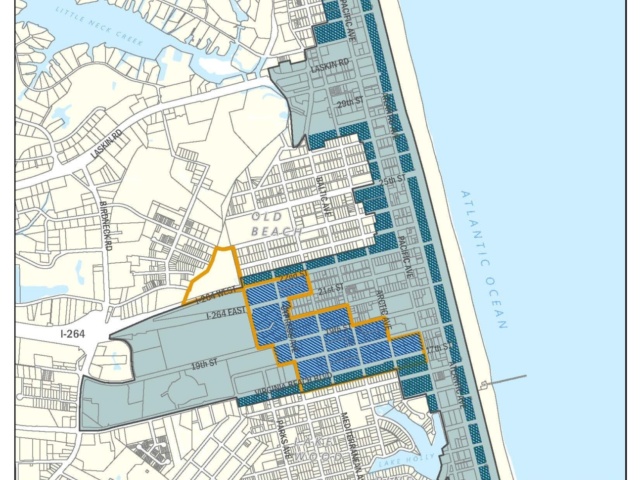
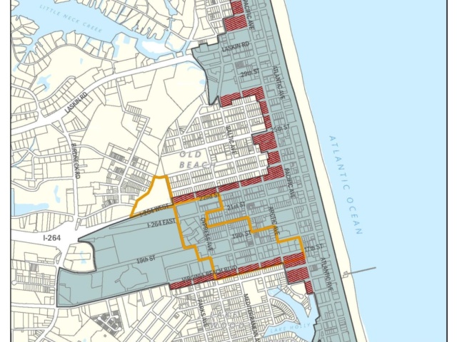
The form-based code contains several provisions protecting residential and apartment districts that are adjacent to the Oceanfront Resort District (“protected districts”) from potentially problematic effects of commercial uses.
These provisions include limitations on or prohibition of certain uses, screening requirements, enhanced setbacks, and access restrictions for commercial uses.
Density: How Much is Too Much?
Optional Forms of Development: Examples
Parking Regulation in the ORD: Flexibility is Key
Refresher Course: How the ORDFBC Works
RT Zoning v. OR Zoning: What's Changed?
Sign Regulations
Maps are in pdf format and are best suited for printing on 11-by-17-inch paper but are not to scale.

Boundary Map
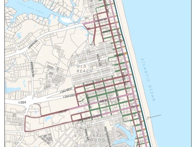
Frontage Map
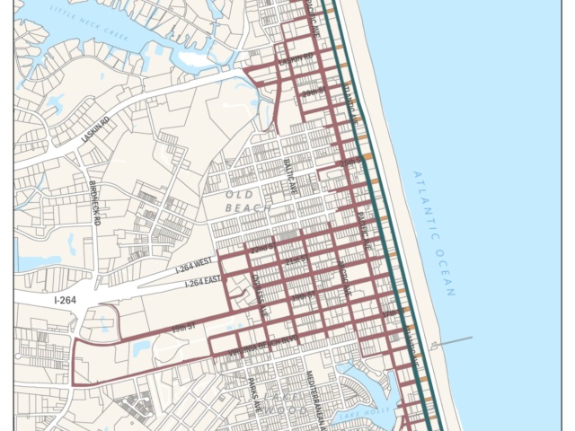
Setback Map
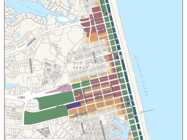
Height Map
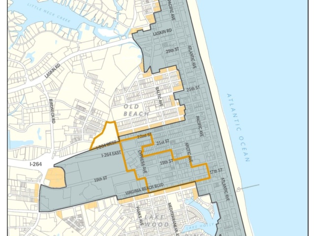
Protected District
Restricted Areas: Commercial Parking Lots
Restricted Areas: Bars/Nightclubs

Restricted Areas: Drive-Throughs